Nearly half a million homes in California risk being in the path of wildfires, according to an analysis that combines U.S. Forest Service data with Zillow housing data. The Forest Service risk map specifically depicts the potential for wildfires that would be difficult to contain.
In California, there are 477,039 homes worth $268.2 billion in areas deemed to have "high" and "very high" wildfire hazard potential. The average value of those homes is more than $550,000, including the land.
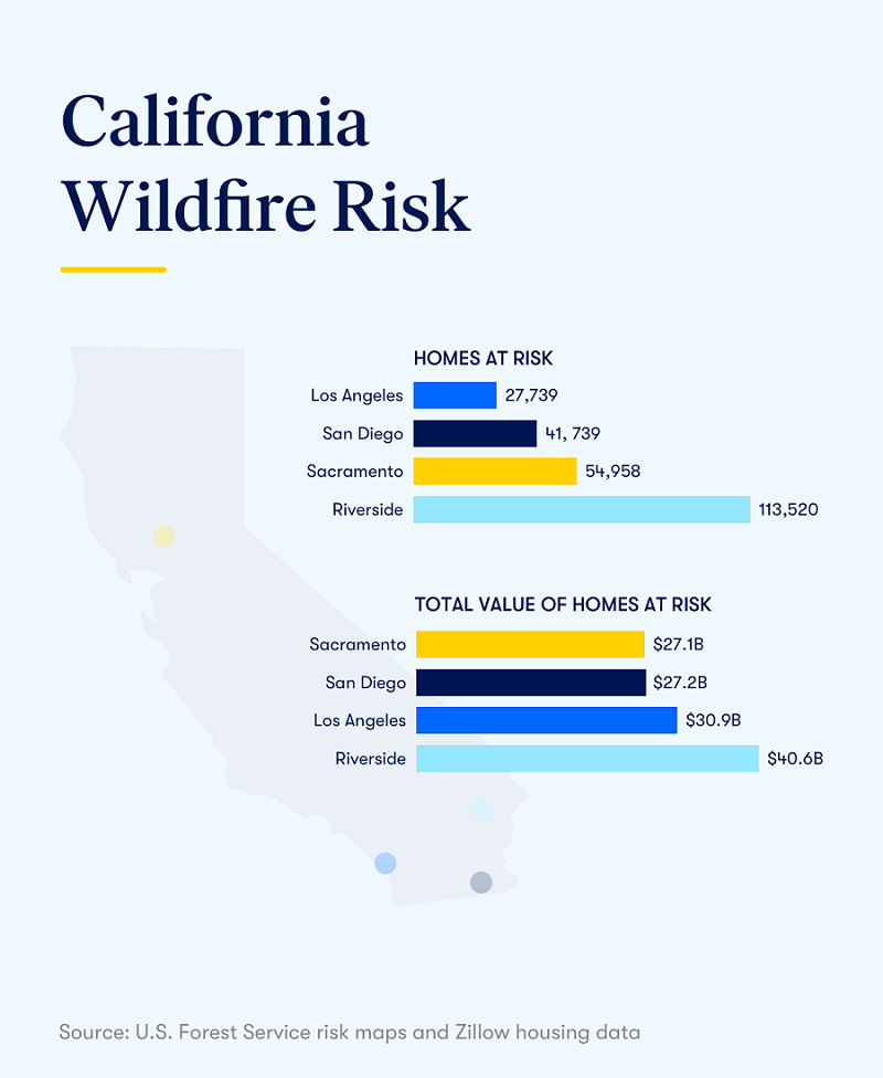
Zooming into the metro level, Zillow analyzed the wildfire risk to homes in four areas: Los Angeles, Riverside, San Diego and Sacramento.
Among those four, Riverside has the most at-risk homes — 113,520 — while the homes at risk in the Los Angeles area have by far the highest average value at more than $1 million.
Federal officials have warned that this year's fire season could be worse than in 2018, when more than 80 people were killed and tens of thousands of structures were burned. The cost of wildfires in 2018 alone was more than $24 billion.
| Metro area | Homes in very high risk areas |
Home in high risk areas |
Value of homes in very high risk areas | Value of homes in high risk areas | % homes in very high risk areas |
% homes in high risk areas |
|---|---|---|---|---|---|---|
| Sacramento | 11,306 | 43,652 | $5.2 billion | $21.9 billion | 1.7% | 6.5% |
| Riverside | 26,254 | 87,266 | $9.2 billion | $31.4 billion | 2.1% | 7.1% |
| Los Angeles | 6,765 | 20,974 | $9.2 billion | $21.7 billion | 0.2% | 0.8% |
| San Diego | 8,472 | 33,267 | $5 billion | $22.1 billon | 1.0% | 4.1% |
| California | 134,428 | 342,611 | $76.7 billion | $191.5 billion | 1.4% | 3.5% |
The post Almost Half a Million California Homes at Risk From Wildfires appeared first on Zillow Research.
via Almost Half a Million California Homes at Risk From Wildfires

No comments:
Post a Comment